Historical Cartotheque
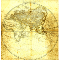
Historical Cartotheque
Archivio Studi Adriatici
La Cartoteca Storica Adriatica CSA è la sezione di BSA costituita dalle mappe e dai portolani antichi dell’Istituto di Studi Adriatici e dalla cartografia prodotta dagli ex Istituti dal 1910 ad oggi, visualizzabile e scaricabile in alta risoluzione e collegata al geoportale BSA CIGnO che contiene le mappe geolocalizzate o georiferite.
The Historical Cartotheque of Adriatic Studies (Cartoteca di Studi Adriatici, CSA) is the BSA section made from ancient maps and pilot books of the Istituto di Studi Adriatici and maps produced by ISA and the other former Institutes from 1910 to date, viewable and downloadable in high resolution and connected for geolocation and georeferenced maps to the geoportal BSA CiGNo.
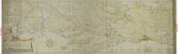
Corografia della Dalmatia
Le linee espresse nel presente dissegno sono tratte da un dissegno conforme, mostrato all’Ill.mo et Ecc.mo Sig.r Commissario Gio. Grimani dall’Ill.mo Sig.r Co: Luigi Ferd. o Marsilij Com.o di S.M.C. che disse essere copia del Dissegno fatto vedere nel Congresso di Carlovitz dall’Ecc.mo Plenip.rio Veneto à Mediatori, quali linee professa detto Sig.r Co: Marsilij essere state tirate co[n] le considerat.ni e riflessi, [et] agl' effetti seguenti.
La Rossa e gialla A è la Linea della proposit.ne fatta pp.re della Ser.ma Rep.ca
La Rossa B è proposit:ne de mediatori, et Imperiali discorsa e no[n] conclusa
La parte di d.a Linea segnata co[n] ponti.C.denota le difficolta, ch'erano insorte per occasione di Marcarsca pretesa da Turchi
La parte di d:a Linea segnata co[n] ponti.D.segna il Paese, che confina alli stati Ragusei preteso da Turchi, [et] ottenuto nella conclusione
La Verde.E.chiude tutto lo Stato di Ragusa
La Rossa.F. e la Linea, che Lui raccordò à Plenip:rij di Cesare p formar il Capitolo ottavo
La Gialla.H.confina le tenute di Castel Novo Risano, & altre in vicina[n]za di Cattaro
Il Color Verde.K.sono le Terre di nuovo acquisto di Zuppa, e Pobori di la da Cattaro e dentro la Linea Gialla
Il Color Rosso.L.sono le Terre d'antico Dominio della Ser:ma Rep.ca in d.e parti.
Scala de Passi Veneti (da 0 a 40000)
Scala di Miglia Italiani, 60 in un Grado di Latitudine (da 0 a 40)
Nota: questa mappa manoscritta e colorata ad acquerello e china ad opera di Giust'Emilio Alberghetti, è una copia conforme della mappa della Dalmazia presentata da Luigi Ferdinando Marsili agli ambasciatori durante le trattative per la Pace di Carlovitz (1699).
Digitalizzazione cura del Laboratorio di Cartografia CIRCE - IUAV di Venezia.
1699

Corso Generale delle Acque fra Adige, la R. Strada da Venezia a Treviso, i Monti ed il Mare.
Mappa ad incisione su carta di Pietro Zuliani, con correzioni ed annotazioni manoscritte: sotto la scala metrica, firma autografa non decifrata dell'Ingegner Capo -??
1800
Corso Generale delle Acque fra Adige, la R. Strada da Venezia a Treviso, i Monti ed il Mare.
Mappa ad incisione su carta di Pietro Zuliani, con correzioni ed annotazioni manoscritte: sotto la scala metrica, firma autografa non decifrata dell'Ingegner Capo -??
1800
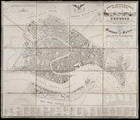
Nuova Planimetria della Città di Venezia
Nuova Planimetria della Città di Venezia dimostrante le divisioni del caseggiato, i dettagli delle Chiese, dei Pubblici Stabilimenti e dei principali Palazzi; e la nomenclatura stradale rilevata sul luogo e disegnata nel 1846 da Bernardo e Gaetano Combatti, corredata da illustrazioni Topografiche Statistiche e Storiche e dalla numerazione anagrafica. Opera compilata in memoria degli Scienziati Italiani riuniti in Venezia nel Settembre 1847. Dedicata a Sua Eccellenza il Nob.e Sig.r Conte Giovanni Correr (...) Podestà della R. Città di Venezia ec.ec.ec..
Digitalizzazione cura del Laboratorio di Cartografia CIRCE - IUAV di Venezia.
1847
Nuova Planimetria della Città di Venezia
Nuova Planimetria della Città di Venezia dimostrante le divisioni del caseggiato, i dettagli delle Chiese, dei Pubblici Stabilimenti e dei principali Palazzi; e la nomenclatura stradale rilevata sul luogo e disegnata nel 1846 da Bernardo e Gaetano Combatti, corredata da illustrazioni Topografiche Statistiche e Storiche e dalla numerazione anagrafica. Opera compilata in memoria degli Scienziati Italiani riuniti in Venezia nel Settembre 1847. Dedicata a Sua Eccellenza il Nob.e Sig.r Conte Giovanni Correr (...) Podestà della R. Città di Venezia ec.ec.ec..
Digitalizzazione cura del Laboratorio di Cartografia CIRCE - IUAV di Venezia.